
/pansyda/dataspec {"status":false}
Data Specifications
This page describes what data and in what format we provide.
Construction phase and full-system phase
PANSY radar started its operation in 2012 during the construction phase. While in this period, until October 2015, the number of antennas were gradually increased and the data quality kept changing. Hence, our data products are split into two parts, construction phase and full-system phase, as in Download.
Observation mode (height region)
PANSY radar has two main observation modes with different target height regions: ST and MES.
- ST (Stratosphere/Troposphere)
- The target height is roughly 1.5 km to 25 km.
- File name starts with 'st'.
- MES (Mesosphere)
- The target height is roughly 40 km to 100 km.
- File name starts with 'mes'.
Embargo period
Data products become available three years after corresponding experiments for both ST/MES mode.
If you are interested in the recent data, please contact us for collaborative research. Please refer to Rules of Use for more information.
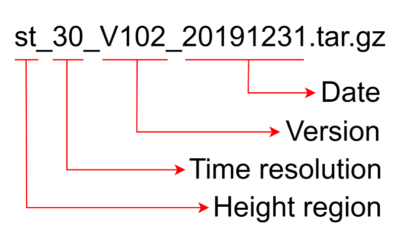
Archive file structure
Data are archived and compressed in tar.gz format per day.
Each file name contains information about height region, time resolution, version, and date on which the data were taken.
Data are provided in NetCDF and CSV format.
They are under separate folders in each tar.gz file.
Files are classified by observation parameter names for each file format.
st_30_V102_20191231.tar.gz
┣ netcdf
┃  ┗ st320nc3
┃      ┗ st_30_V102_20191231.nc
┗ csv
    ┗ st320nc3
        ┗ st_30_V102_20191231.csv
Contents of each data file
Version 1.02
This version contains radial wind velocity (wind), echo intensity (echo), detectability value (dtc1), and noise floor level (nois) for each beam.
In the header of NetCDF files, you will find the information like below:
netcdf st_03_V102_20150930 {
dimensions:
        time = 224 ;
        range = 124 ;
        beam = 5 ;
variables:
        int time(time) ;
                time:units = "seconds since 2000-01-01 00:00:00" ;
        float range(range) ;
                range:units = "km" ;
                range:long_name = "Range" ;
        int beam(beam) ;
        float wind(beam, range, time) ;
                wind:long_name = "Radial Wind Velocity" ;
                wind:standard_name = "radial_wind_velocity" ;
                wind:units = "m s**-1" ;
                wind:missing_value = 999. ;
        float echo(beam, range, time) ;
                echo:long_name = "Echo Power" ;
                echo:standard_name = "echo_power" ;
                echo:units = "dB" ;
                echo:missing_value = 999. ;
        float dtc1(beam, range, time) ;
                dtc1:long_name = "Detectability" ;
                dtc1:standard_name = "detectability" ;
                dtc1:units = "" ;
                dtc1:missing_value = 999. ;
        float nois(beam, time) ;
                nois:long_name = "Noise Level" ;
                nois:standard_name = "noise_level" ;
                nois:units = "dB" ;
                nois:missing_value = 999. ;
// global attributes:
                :Azimuth_Angle_deg = 0, 0, 90, 180, 270 ;
                :Zenith_Angle_deg = 0, 10, 10, 10, 10 ;
                :Number_of_Coherent_Integration = 64 ;
                :Number_of_Incoherent_Integration = 7 ;
                :Version = "1.0.2" ;
                :Number_of_FFT = 128 ;
                :IPP_us = 320 ;
                :Subpulse_Width_us = 1 ;
                :Number_of_Subpulse = 16 ;
                :Observation_Parameter = "st320nc3" ;
...
}
CSV files are formatted as follows:
beam,range(km),time,wind(m/s)
1,  1.50,2018-05-30 00:00:21, -0.24
1,  1.50,2018-05-30 00:04:06,  0.01
1,  1.50,2018-05-30 00:07:50, -0.12
...
Note CSV files do not contain parameters other than wind.
Calibration of echo intensities
The derivation of wind components and quality control are performed based on the signal-to-noise ratio (SNR), and we do not provide any calibrations on echo intensities. However, one can estimate what noise floor level corresponds to some physical parameters, such as the theoretical galactic noise temperature, using a global diffuse sky model and antenna array specifications.
You can find an example application here: pansy-galnoi (Jumps to GitHub)
DISCLAIMER: We do not guarantee the correctness of this program! This is just an example...